Evidence and Documents
This website brings together source documents, maps, correspondence, government records and community research relating to the proposed Gonneville development and its associated infrastructure.
Wherever possible, we link directly to the original source so you can read the evidence and make up your own mind.
Don’t just take our word for it. Read the evidence.
THE INFRASTRUCTURE CORRIDOR
This is not an empty landscape.
The proposed Gonneville infrastructure corridor crosses established private properties containing homes, native vegetation and areas specifically protected from clearing.
Some families have lived on these properties for many years. Others purchased and moved into their properties only recently.
In parts of Maryville Heights, landholders purchased properties containing Tree Preservation Areas — vegetation they were required to protect as part of the subdivision.
The proposed corridor now cuts across this same landscape.
For affected landholders, this is not simply a line on a map.
It raises questions about clearing, permanent infrastructure, access and maintenance requirements, wildlife habitat, ecological connectivity and the future use and character of their properties.
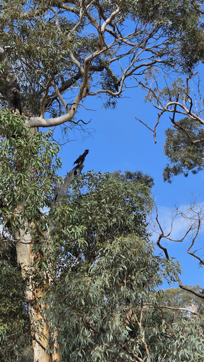
These areas also provide habitat for native wildlife, including threatened black cockatoos.
Below we document what is proposed, what is already there, and what could be permanently changed.
63km LONG. 100 METRE WIDE.
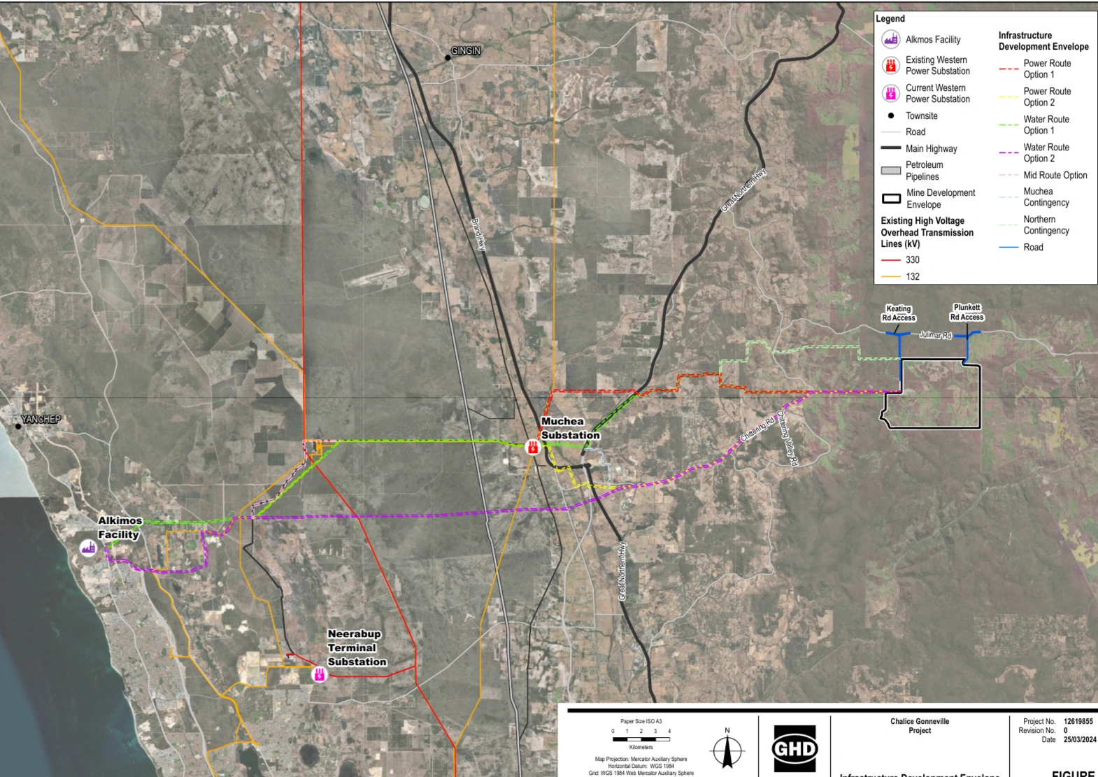
CHALICE’S INFRASTRUCTURE DEVELOPMENT ENVELOPE
Source: Gonneville Project Proposal Content Document, Figure 3 — March 2024
PRIVATE PROPERTIES. ESTABLISHED HOMES.
The proposed infrastructure corridor does not simply cross vacant or undeveloped land.
Along parts of the proposed route are established private properties and homes. Some families have lived on these properties for many years. Others purchased properties and moved in only recently, before becoming aware that major mine-related infrastructure was being investigated across or alongside their land.
For affected landholders, the issue is not simply where a line appears on a project map. It is what construction, clearing, access, maintenance and permanent infrastructure could mean for the future use, amenity and character of their properties.
The evidence in the sections below documents what landholders were told, when they were told, what is proposed for their properties, and the protections and environmental values already attached to some of this land.
TREE PRESERVATION AREAS
Some properties along the proposed corridor contain areas of native vegetation identified as Tree Preservation Areas as part of the Maryville Heights subdivision.
These areas were not simply leftover vegetation. Their protection formed part of the environmental planning for the subdivision, and affected landholders purchased properties with restrictions and responsibilities relating to the protection of trees and native vegetation.
For some landholders, that protected vegetation and the wildlife habitat it provides was part of the reason they chose to buy and live there.
The proposed Gonneville infrastructure corridor now intersects this same landscape.
This raises an important question: how can landholders be required to protect vegetation on their properties
BLACK COCKATOOS & BREEDING HABITAT
The proposed infrastructure corridor passes through and alongside habitat used by threatened black cockatoos.
Mature native trees in this landscape provide more than visual amenity. They can provide feeding habitat, roosting habitat and, where suitable hollows occur, potential or confirmed breeding habitat.
Carnaby’s Black-Cockatoos and Forest Red-tailed Black-Cockatoos are recorded in the wider area, and breeding hollows have been identified within the Tree Preservation Area affected by the proposed corridor.
The potential impact therefore extends beyond the number
WHAT WOULD THE CORRIDOR ACTUALLY CONTAIN?
The proposed infrastructure corridor is intended to carry much more than a single piece of infrastructure.
Current project material identifies a high-voltage electricity transmission line and a water pipeline as key components of the corridor, together with the access and supporting infrastructure required for construction, operation and maintenance.
POWER INFRASTRUCTURE
The proposed corridor would include a high-voltage electricity transmission connection between Gonneville and the electricity network near Muchea.
The current proposal includes a 132 kV dual-circuit transmission line. For affected properties, the potential impact is therefore not limited to vegetation clearing: it includes the transmission structures, associated access and the ongoing requirements of operating and maintaining the line.
The location, design and final disturbance footprint remain important because the proposed route passes through an established semi-rural landscape containing homes, native vegetation and wildlife habitat.
FUTURE-PROOFING
Questions have also been raised about whether infrastructure established for Gonneville could form part of, or facilitate, larger future electricity-network development in the Chittering–Muchea area.
This matters to affected landholders because the long-term purpose and potential future use of an infrastructure corridor can be just as important as the infrastructure proposed at the time approvals are sought.
Any future expansion should therefore be clearly distinguished from the infrastructure currently proposed for Gonneville, with the purpose, capacity and potential long-term use of the corridor made transparent.
WHAT THE PROJECT DOCUMENTS SHOW
Chalice’s Pre-Feasibility Study identifies a staged approach to electricity supply.
Stage 1 is proposed to rely primarily on on-site generation and battery storage. Stage 2 would require connection to the South West Interconnected System.
The PFS identifies the State Government’s planned Clean Energy Link – Chittering and a proposed new terminal near Muchea as the infrastructure expected to enable that Stage 2 grid connection.
This creates an important distinction: the transmission infrastructure currently proposed for Gonneville should be considered alongside the wider electricity-network development already identified in the project’s own planning.
For communities and landholders along the corridor, the long-term relationship between the Gonneville connection and future network infrastructure needs to be clearly explained.
ACCESS & MAINTENANCE
The infrastructure corridor is not only about the powerline and water pipeline.
Construction, inspection, maintenance and operation of that infrastructure also require access. This raises separate questions about where access tracks would be located, how wide they would be, what vegetation would need to be cleared, and whether those access roads would remain for the operational life of the infrastructure.
For landholders, these details matter. The impact of a corridor cannot be understood simply by looking at the width of a pipeline or the footprint of a transmission structure. The associated construction and ongoing road access requirements must also be considered.
COMPENSATION AND PRIVATE LAND
Chalice's Landholder Guide states that compensation for infrastructure on private land would be determined by agreement between Chalice and the landholder or, if agreement cannot be reached, by an amount determined by the Warden's Court.
It states that proposed compensation arrangements would be documented through a private access agreement.
Chalice state there is no land acquisition for landowners whose property is proposed to have the 100m wide corridor easement over their land.
WHAT ABOUT LOSS OF PROPERTY VALUE AND ENJOYMENT OF YOUR HOME?
For landholders living beside or affected by the proposed corridor, the impacts may extend well beyond the land physically used for infrastructure.
Concerns include loss of amenity and enjoyment of the property, changes to outlook and character, noise and disturbance, and potential effects on property value.
Chalice’s Landholder Guide explains compensation for impacts caused by mining activities, but it does not make clear on this page whether, or to what extent, these wider impacts would be compensated.
For affected families, that is a significant unanswered question.
HOW WAS THE PREFERRED CORRIDOR CHOSEN?
In March 2024, the Gonneville Project referral contained multiple infrastructure corridor options for water and power.
By 2026, Chalice had identified a single preferred corridor.
But important information behind that decision is still not publicly available, including the complete route comparison, detailed Multi Criteria Evaluation, supporting maps for the current Commonwealth variation, and the reasons individual alternatives were rejected.
This investigation follows what changed between the original 2024 referral and the proposal being assessed today — and identifies the questions that remain unanswered.
WHAT CHANGED BETWEEN 2024 AND 2026?
The proposal now being assessed is not identical to the project originally referred in March 2024.
Chalice has confirmed it has submitted a Section 156A variation to the Commonwealth and a Section 43A amendment to the WA environmental assessment.
Changes identified by Chalice include:
water and power infrastructure consolidated into a single preferred corridor
changes to the proposed clearing footprint
removal of underground mining from the current proposal
addition of a solar farm for internal power generation
mine life reduced from 25 years to 23 years based on PFS modelling
updated maximum greenhouse-gas emissions estimates.
The Commonwealth variation is currently under assessment. Chalice has advised that the variation application and supporting maps cannot presently be provided and will be made publicly available on the EPBC Act Public Portal if the variation is approved.
So the public currently knows that the proposal has changed but cannot yet examine the complete Commonwealth variation documents showing exactly what is being assessed.
WHAT DID THE ORIGINAL 2024 REFERRAL SAY ABOUT CHOOSING THE CORRIDOR?
In the March 2024 Referral Supporting Document, Chalice said infrastructure corridor options had been developed using a Multi Criteria Evaluation (MCE).
The assessment considered a range of factors including environmental impacts, social and cultural heritage impacts, engineering and technical requirements, cost, operational expenditure and project schedule risk.
Importantly, under environmental impacts the MCE specifically included:
“identifying potential alignments within existing disturbed areas”
The original referral therefore shows that using existing disturbed areas was expressly part of the corridor-selection considerations.
That raises an important question about the preferred alignment identified in 2026:
What existing disturbed corridors and road reserves were assessed as alternatives, and why were they rejected in favour of an alignment affecting private properties and areas of native vegetation?
Chalice now says further detail about the alternatives considered and the route-selection process will be presented in the Public Environmental Report, where appropriate.
Until that information is published, the community cannot independently compare the preferred corridor with the alternatives that were considered.
NOT ALL ROUTE OPTIONS RECEIVED THE SAME ON-GROUND SURVEY ACCESS
Chalice has confirmed that flora and fauna surveys were undertaken along potential infrastructure corridors during Spring 2025.
However, on-ground surveys could only be undertaken where landowners granted access.
Where access was not provided, Chalice says a desktop assessment was, or will be, undertaken using aerial imagery and existing publicly available information.
This raises an important question about how alternative corridors were compared.
If one potential alignment received detailed on-ground flora and fauna surveys while another was assessed using desktop information, how was Chalice able to ensure the environmental comparison between those routes was equivalent?
Desktop information may identify broad vegetation and landscape features, but it does not necessarily provide the same site-specific information as an on-ground survey.
When the Public Environmental Report is released, the community should be able to see:
which parts of each alternative corridor were surveyed on the ground
which areas relied on desktop assessment
what environmental information was available for each route
any limitations or gaps in the survey data
how differences in survey effort were accounted for when comparing alternatives.
WHERE DOES THIS STAND NOW?
As at 18 September 2026:
Chalice has identified a preferred infrastructure corridor.
The preferred corridor is NOT a final government-approved route.
The Commonwealth Section 156A variation is still under assessment.
The complete variation application and supporting maps are not currently publicly available.
The Public Environmental Review has not been completed.
Detailed information explaining the comparison of alternative corridors is still to come.
A preferred route is not an approved route.
The evidence used to select it, and the alternatives that were rejected, still matters.