
WATER DOESN’T STOP AT THE MINE BOUNDARY
Gonneville’s own environmental documents show where the water goes. The question is what happens when a major open-cut mine, waste rock landforms, processing infrastructure and a vast tailings storage facility are built across that drainage landscape.
Water falling on the proposed Gonneville mine site does not simply stay there. Chalice’s own environmental referral states that the Mine Development Envelope sits within the Avon River catchment. Approximately 62% drains into Julimar Brook, while the remaining 38% drains through two unnamed tributaries of the Brockman River.
Both Julimar Brook and the Brockman River system flow south through rural properties before discharging into the Avon River.
That makes the waterways surrounding Gonneville more than lines on a map. They are part of a connected catchment extending well beyond the proposed mine boundary.
So we followed the water.
THE SAME LANDSCAPE. TWO VERY DIFFERENT MAPS
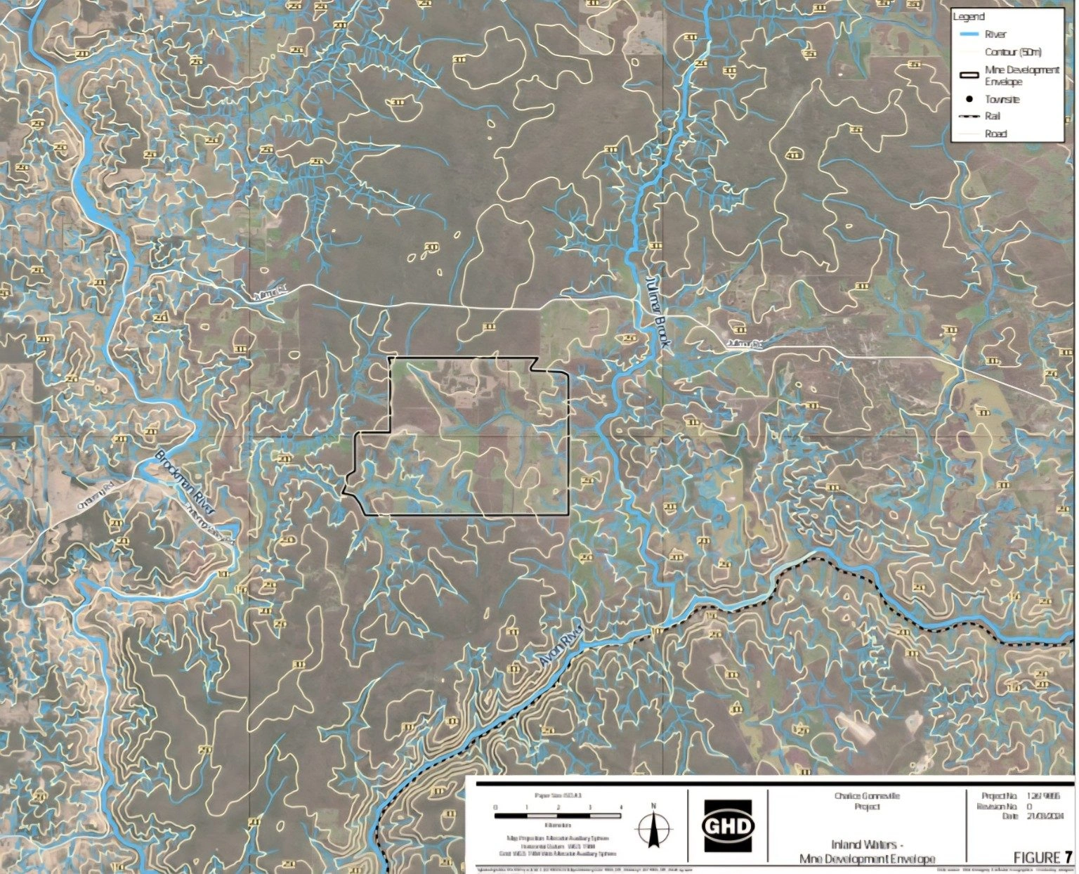
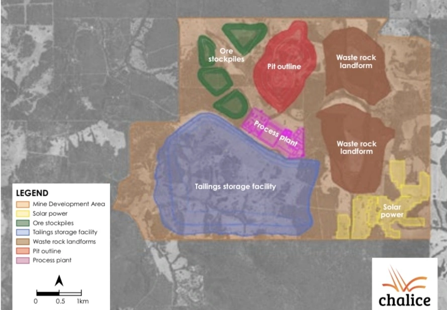
Two maps. The same landscape.
The first is Chalice’s own Inland Waters mapping, showing the natural drainage network running through and around the proposed Mine Development Envelope.
The second is Chalice’s preliminary mine layout, showing what is proposed across that landscape: a major open pit, processing plant, ore stockpiles, two large waste rock landforms and a substantial valley-fill tailings storage facility.
Chalice states that approximately 62% of the Mine Development Envelope drains into Julimar Brook, while the remaining 38% drains through two unnamed tributaries of the Brockman River. Both ultimately discharge into the Avon River.
One map shows where the water naturally moves.
The other shows what is proposed to be built across that landscape.
The water doesn’t disappear because the landscape becomes a mine.
THE WATER DOESN’T DISAPPEAR
Chalice’s own documents identify the potential for changes to surface-water catchments, sediment entering streams and acidic, saline and/or metalliferous drainage associated with mine waste and tailings.
The mine boundary does not create a hydrological boundary.
Whatever Gonneville eventually looks like, rainfall will continue to fall across this landscape and water will continue to follow gravity. The difference is that the landscape it moves across will have been profoundly altered by a major open pit, waste rock landforms, processing infrastructure, stockpiles and a valley-fill tailings storage facility.
That is why what happens to water at Gonneville matters far beyond the lines drawn around the mine.
A VALLEY FILLED WITH TAILINGS
One of the largest features shown on Chalice’s preliminary mine layout is the proposed tailings storage facility.
This is not simply a large pond. Chalice describes a facility constructed progressively in stages using a downstream, valley-fill design, with capacity for the tailings generated over the modelled open-pit mine life.
Earlier environmental documentation provided for up to 300 million tonnes of cumulative tailings over 25 years.
Its significance to this investigation is not simply its enormous scale. It is where it sits: within the same landscape Chalice’s own mapping shows is crossed by natural drainage pathways forming part of the wider Avon River catchment.
And water is inseparable from the way a tailings facility operates.
Rain falls on it. Water is associated with the deposited tailings. Runoff must be managed. And the facility remains part of the landscape long after mining ends.
No company can guarantee that a tailings facility will never fail.
The real question is what happens if containment does fail, because at Gonneville, Chalice’s own mapping already tells us where the water goes.
WATER MOVES ABOVE GROUND AND BELOW IT
Surface water is only half the story.
Chalice’s own environmental referral describes shallow, unconfined groundwater associated with the modern drainage lines, as well as groundwater within weathered bedrock and potentially interconnected fractured rock.
That matters because Gonneville would not only transform the surface landscape. Mining would extend deep below it, and Chalice itself identifies groundwater drawdown associated with the open pit as a potential impact to inland waters.
So there are two water stories at Gonneville: rainfall and runoff moving across the altered landscape, and groundwater moving beneath it.
Water does not recognise the line around a Mine Development Envelope, above ground or below it.
FOLLOW THE WATER DOWNSTREAM
The drainage lines crossing Gonneville do not end at the edge of the proposed mine.
Chalice’s own mapping shows the majority of the Mine Development Envelope draining towards Julimar Brook, with the remainder draining through tributaries of the Brockman River. Both systems ultimately connect with the Avon River.
That does not mean that any release from Gonneville would automatically reach the Avon River, or travel further downstream. What moved, how far it moved and in what concentration would depend on rainfall, flow conditions, the material involved, containment and many other factors.
But the hydrological connection itself is important.
Gonneville is not an isolated industrial site surrounded by a neat environmental boundary. It sits within a connected catchment, with water leaving the landscape through waterways that continue through rural properties and into a much larger river system.
When assessing risk to water, the investigation cannot reasonably stop at the mine fence.
The water certainly doesn’t.
WHAT COULD ENTER THE WATER?
The concern is not simply that water moves through this landscape. It is what that water could potentially carry with it.
Chalice’s own environmental documentation identifies potential impacts including sediment entering streams and acidic, saline and/or metalliferous drainage associated with waste rock landforms and tailings storage.
Those words matter.
Gonneville would introduce enormous volumes of excavated rock, processed material and mine waste into a landscape already dissected by natural drainage lines.
This does not mean contamination will occur. But it does mean the potential pathways are significant enough to have been identified in Chalice’s own environmental assessment.
And once again, the water does not stop at the mine boundary.
WHEN THE RAIN COMES
For much of the year, some of these drainage lines may appear quiet. But that does not make them irrelevant.
They exist because this landscape drains.
When significant rain falls, water moves across the catchment, into drainage lines and downstream. The greater the rainfall and runoff, the more important the relationship between the mine landscape and the surrounding waterways becomes.
Gonneville would fundamentally alter that landscape. Natural ground would be replaced in places by an open pit, waste rock landforms, stockpiles, processing areas, roads and a large valley-fill tailings storage facility.
Those changes do not stop the rain.
They change the landscape the rain falls on.
And ultimately, gravity still decides which way the water wants to go.
THE BOUNDARY IS ON THE MAP. THE WATER ISN’T.
Chalice can draw a boundary around Gonneville.
Water will not follow it.
Chalice’s own documents show a mine proposed within a connected catchment, with natural drainage towards Julimar Brook and the Brockman River system and ultimately the Avon River. They also identify potential impacts involving sediment, changes to catchments, groundwater drawdown and acidic, saline and/or metalliferous drainage from mine waste and tailings.
None of that proves those impacts will occur.
But it does demonstrate why Gonneville cannot be considered only within the lines of its Mine Development Envelope.
The pit may have a boundary. The tailings facility may have a boundary.
The catchment does not.
Follow the water.